 |
|
| Chamonix
to Zermatt Walker's Haute Route |
| Difficulty Dates Maximum
Ratio See also: |
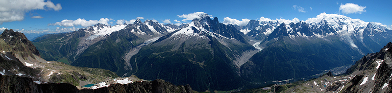
The famous Haute Route trek between the resort towns of Chamonix in France, and Zermatt in Switzerland, has followed nearly endless variations since it was pioneered in the mid-19th century. The walker's variation we have chosen here has the virtue of taking us through the most spectacular scenery while allowing us to avoid the technical and glaciated terrain of the "High Level Route" (see definitions below). We pass through rustic villages that retain their centuries-old charm and rural way of life; wildlife abounds in the high alpine meadows, giving us good odds of seeing ibex, chamois, marmots, eagles and more. Every day but one ends in a comfortable hotel or inn with all the amenities, allowing us to carry only relatively light day packs; finally, our strategic use of cable cars, taxi, bus and train transfers means we can complete the route in a 9-day trip. What exactly is the Chamonix to Zermatt Haute Route? Actually there are three distinct Haute Routes commonly done, and we offer programs for all three:
The route described here is the latter. Less arduous and technical than the High Level Route, it is attainable by the very fit and adventurous hiker who has not acquired mountaineering skills. However, although more accessible, this is still a very tough trek. We cover a lot of distance every day, up to almost 17 kilometers some days. We cross high passes and descend far down into the valleys; our trail is not always well marked nor easy, and includes rough rocky sections, boulders, perhaps even occasional snow. Some days may see us climbing ladders or using cable handrails. Spectacular situations and awe-inspiring views are the order of the day, and every day brings challenge and discovery. There are two nights in true mountain huts. The remainder of the nights are in comfortable hotels and gites.
Booking your trip We offer this trip as either an open trip, on which you can sign up by yourself and join a group, or, as a private program for just you and your friends/family. For booking either an "open" trip or a private trip, you can fide more information on the booking procedure here, Booking Trekking Information. Guiding fees are the same for either an open trip or a private trip. Fee information for the Walker's Chamonix to Zermatt Haute Route can be found here. Group size and composition Kathy can take a maximum of 8 trekkers. We are happy to run the trip with as few as a single trekker. However, as you can see from the fee structure, the price varies with the number of trekkers. |
|||||
| Nature of hazards
and difficulty |
The Walker's Haute Route is a long and demanding trip requiring very good physical fitness and preparation. We cover from 10 to almost 17 kilometers most days, through great changes in elevation; ups and downs per day are usually well in excess of 3000 feet, and often more than 4000 feet (1200 meters). Some of the trails are quite rough, involving movement over boulders, rocky slabs and possibly even some snow, especially if you schedule your trip before the end of July. We prefer to offer this trip in early September, when the weather is typically dry and relatively warm, Even in the summer, however, new snow is possible especially at higher elevations, and this can make travel considerably more difficult. Good endurance, balance, and agility are required to get safely and comfortably through the toughest days. The most significant hazard is injury resulting from a misstep or a short slip or fall. Weather and temperature extremes also can entail hazards we must be prepared to manage. Proper clothes, and care in keeping warm without sweating, should help us to avoid many problems. Much more common, but not so life-threatening, are blisters and sunburn. |
Prerequisite Skills |
This is a trip for experienced and very fit walkers. Most important prerequisites are a very good level of fitness and stamina. Agility, a head for heights, and a sense of adventure are also very helpful. If you have any questions about the appropriateness of this trip for you, please contact us. |
 |
|
| Summer blooms in the upper Val d'Hérens. | |
| Chamonix
to Zermatt Walker's Haute Route
|
|||||
| Day 0 | Rendezvous in Chamonix, evening meal and night in the hotel. |
||||
| Day 1 | Montroc to Trient There are several ways to begin our trek. Our preferred route, assuming the weather is reasonable, is over the l'Aiguillette des Posettes, past the Croix de Fer and down to Trient. We begin with a short bus transfer from Chamonix up valley to the hamlet of Montroc le Planet (fantastic name we think), and hike up above treeline to the summit of the Posettes. This is a wonderful walk, through alpine meadows along a fine ridge with constant 360 degree views. A short descent leads to the Col de Balme, where we say good-bye to France and step into Switzerland. After a pause in the col, we climb a bit more passing the Croix de Fer before descending into the Trient valley, and to our hotel.
|
||||
| Day 2 | To Champex This is a big day. We begin with a steady climb over the Fenêtre d'Arpette. We are cheered on our way by the nearby views of high glaciers, and by our steady uphill progress. After a pause for views at the col, a long descent down the Val d'Arpette brings us through scattered larch forests, into deeper evergreen woods and finally to our hotel in the small town of Champex.
|
||||
| Day 3 | Verbier to Cabane Louvie In the morning we will be met by a taxi to take us to Le Chable where we ride the cable car and chair lifts to about 2250 meters. We then follow an easy trail, wandering up through meadows, into a rocky cirque and finally over the Col Termin. A shorter descent brings us to the lake and Cabane de Louvie.
|
||||
| Day 4 | Cabane Louvie to Cabane de Prafleuri This long and rather tough day takes us over two passes, and across sparse track, at times exposed, at times rough and bouldery, perhaps even some snow to deal with. We are rewarded at the end of the day by a comfortable night in the charming Prafleuri hut.
|
||||
| Day 5 |
Cabane de Prafleuri to Arolla This is another long day ending in a beautiful old hotel in a quiet and remote village. We begin by climbing over the Col des Roux, then contouring around the Lac des Dix, to pass around its southern end. Our trail then climbs the western slopes of the Monts Rouges, gradually nearing the edge of the stagnant and boulder-covered lower Cheilon Glacier. Trail markings keep us on track in this confusing maze of rocks. We climb either up over the steep metal stairway to the Pas de Chèvres. From here it's a long descent through tumbling stream drainages and flowery meadows to our grand old hotel tucked deep within mature larch forest in Arolla.
|
||||
| Day 6 | Mayens du Cotter to Grimentz This morning starts with a taxi ride down the steep and winding road out of the Arolla Valley, to a fork in the upper reaches of the Val d'Hérens. The Val d'Hérens is one of several high mountain valleys penetrating deep into the Alps southward toward the crest and border with Italy, and which run roughly parallel to the famous Mattertal further east. In fact this days' walk will bring us over a ridge crest to the equally beautiful and unspoiled Val d'Anniviers, the next jump eastward. Unlike the Mattertal whose upstream terminus is the high-end resort of Zermatt, the towns tucked high in these other valleys retain much of their rustic charm, peace and quiet. We'll get a sample of this as we transfer to our trailhead above the village of Evolène. The taxi drops us at the cluster of barns called Meyens du Cotter. We climb up to, and cross the Col de Torrent, and if we are lucky with the weather we'll enjoy some of the best views of the trip so far, from Mont Blanc behind us, to the dominating Dent Blanche and Grand Cornier closer by. We are in the midst of a real connoisseurs' alpine playground, and tantalizingly close to Zermatt and the Matterhorn, if only we could fly like the eagles we might also be lucky enough to see! We descend past the Alpage de Torrent, and to the dam at the Moiry reservoir. From the dam we can either catch the Post Bus, or if we are still feeling spry, walk the final 5 km to Grimentz.
|
||||
| Day 7 | St Luc to Gruben Today's climb jumps a ridge that rises to the spectacular snowy pyramid of the Weisshorn. We may get our first views of the Matterhorn during this climb. From our high point at the Meidpass, we descend into the last and most remote of our parallel valleys, the Turtmanntal, to spend the night in the summer village of Gruben.
|
||||
| Day 8 | Gruben to St. Niklaus - (cable car at the end) and train to Zermatt After one more big climb over the high Augstbord pass, we are finally within reach of the end of our journey. At the top we are met by a new vista of 4000 meter peaks. Just across the valley is the sharply chiseled Mischabel range separating the Mattertal from the Saas valley. Further up the Mattertal our view is dominated by the Breithorn, one of the giants above Zermatt. A last rugged descent among rocky ridges and basins brings us at long last to a cable car, which we take down to St. Niklaus. We'll catch the train in St Niklaus which will take us to Zermatt. After a good hot shower and celebration dinner, it's time for a long and well deserved night's rest.
|
||||
| Day 9 | Zermatt-based hike We have decided to include a day for hiking in the Zermatt area. There are such incredibly good options, that it seems ashamed to be even slightly tempted to head home. Some of our favorite walks: (from easy to hard)
|
||||
 |
|
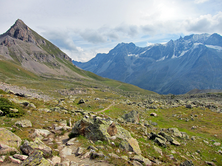
| Descending the high alpage from the Pas de Chèvres to Arolla. | |
 |
|
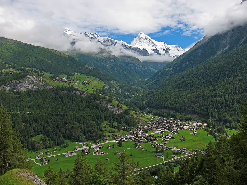
| A glimpse of the Dent Blanche above the village of Les Haudères. | |
 |
Kathy Cosley & Mark Houston AMGA Certified • SNGM members All images, layout and text ©2009 Cosley & Houston Alpine Guides, All Rights Reserved |
|
 |
|
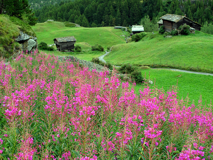
| Fireweed above Zermatt. | |